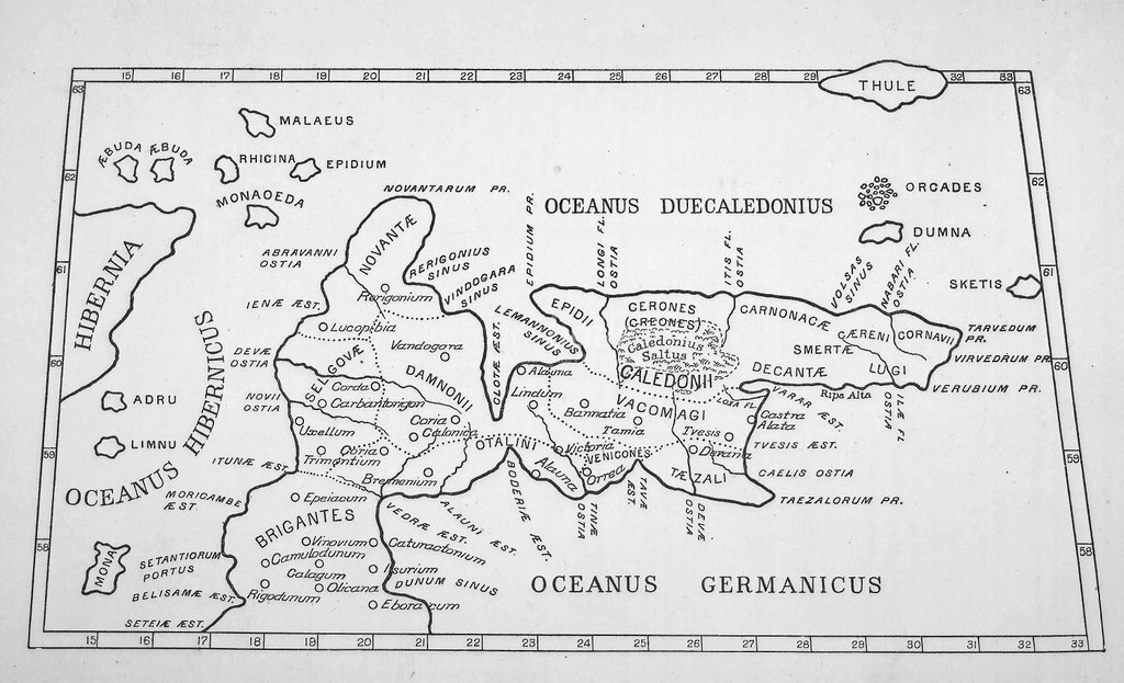
ID:QZP40_941_006_P002DESCRIPTION:Claudius Ptolemy, a 2nd century Roman geographer, was one of the first scientific map makers. Using existing research as well as his own new theories, he created a series of tables showing place names, longitude and latitude.
On his map of Britain the outlines of England and Ireland are extremely accurate. Scotland, however, is placed at a right angle to England and runs west to east instead of south to north, as can be seen in this image. Something similar happens in his map of Denmark which has led to the suggestion that these countries have been drawn using data taken from the sea whereas the other countries, which were part of the Roman Empire and accessible to him, were drawn using data taken from the land. The sea data was less accurate as tides and currents had to be taken into consideration.
Another explanation was that the maps of England, Scotland and Ireland were drawn separately and in putting them together Ireland was placed too far north which forced Scotland to be placed at right angles to England.
Ptolemy's map shows the names of places and of the native Celtic tribes. According to Ptolemy there were ten tribes north of the River Forth and seven to the south. The southern tribes were a part of the Roman province of Britannia but the northern tribes were not.
The map is from volume XVIII of the Transactions of the Gaelic Society of Inverness, 1891-1892PLACENAME:Dun Carloway and Dun CromoreCREATOR (AV):PtolemyDATE OF IMAGE:1792PERIOD:2nd centurySOURCE:Highland LibrariesCOLLECTION:Fraser Mackintosh Collection (maps)Asset ID:42636KEYWORDS:
Your download will start shortly, please do not navigate away from this page until the download prompt has appeared. Doing so may cause your download to be interrupted.
We use cookies to ensure that we give you the best experience on our website. If you continue to use this site we will assume that you are happy with it.Ok